POMONA, A SITE OF THE CLASSIC MAYA
Within this overall picture is that we can locate Pomona, ancient Mayan city.
In the beginning was a small farming village a few miles west of the great river Usumacinta place where it enters the coastal plain of the Gulf of Mexico, there the river becomes calm and gentle meanderings trace to reach the sea. As a political entity flourished between 600 to 800 AD Today is located in the town of Tenosique, in the state of Tabasco.
The importance of this archaeological site lies in the wealth of hieroglyphic inscriptions found that not only give us a chronology of their development but also information on their leaders and their relationships with other cities of that era, such as Palenque and Piedras Negras, relationships which, incidentally, were not always peaceful.
ARCHITECTURE
The core of monumental architecture was constructed on a series of mounds of gravel of fluvial origin. It is composed of six major architectural complexes, along with residential areas covering about 175 hectares.
The area was developed and participated Pomona was named "Usumacinta province": there are several important sites have been identified whose inscriptions emblem glyph given name: Palenque, Tonina, Piedras Negras, Yaxchil'na, Bonampak, Lacanha and, of course, Pomona. Each of these formed a political entity with its own government, territory and population. This is the pattern identified for the Late Classic Period (600 to 900 AD) in the Mayan area.
In the course of his political and military history, Pomona, as narrated in the hieroglyphic texts, depended mainly on Palenque. When you start a war with Piedras Negras, was defeated.
This city, like Panjal or Chinikiha (the latter two sites among several others are yet to explore), was at the beginning of the lower Usumacinta, and obviously played an important role in political and economic terms, since it served as a door entry to high Usumacinta, and therefore a significant portion of the Peten, access point products toward the coastal plain.
In Pomona there were considerable agricultural resources, due to be in a region of alluvial deposits. The Maya developed a unique technology for better harvests in different circumstances, such as terraces, raised fields and other practices that enabled them to succeed in difficult terrain.
EXPLORATION
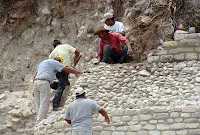 Of the six groups of buildings throughout the site, currently only one has been explored and consolidated. It is situated at the northern end, consisting of thirteen buildings that are distributed on three sides of a rectangular square. It is bordered by a large base quadrangular pyramid with seven bodies staggered vertical walls. Its main facade is oriented to the south, where rudeness is limited by the stairway balustrades. At the bottom and in front of this one is a circular altar, mounted on four supports it off the floor.
In the center of the plaza sits a low altar, whose characteristics are most important to have a first slope-shaped body and a second group with a board, both in lower and upper section there are wide moldings. Another notable elements of this building, and rare in this region, is to have four staircases with balustrades one per facade.
The western end of the square is bounded by five large buildings, oriented to the east. Each consists of a basement with stairs and into the upper section a temple covered with a dome.
From this set, no doubt building 4 is the most complex of Pomona, the front has stairs with ramps leading to the top of the stepped base. There also stands the temple with stairs and ramps, and in the latter there are four monumental inscriptions which represents the Kin, the Sun In the top section were the outbursts of the temple walls were composed of two bays and three access openings covered by the system of fake Mayan vault or arch. Inside were located sculptural panels representing richly dressed characters, with hieroglyphic inscriptions.
At the other end of the square, on the east side are low platforms that limit the space. Outstanding among them was a small basement that is peculiar characteristics, composed of three whose corners are tucked in, with three edges instead of one. This type of construction is associated with earlier periods of Mayan architecture.
The south end of the square is covered, but with access stairs, as if the whole set more distant relationship with others that are located in the same direction within Pomona.
THE MUSEUM
This site has a small museum, which also show the objects recovered during exploration, a collection of pieces which offers the visitor an overview of archaeological finds in that region.
Maler Teobert In 1898, Austrian photographer, relates that took as its point of departure for his expedition to the Mayan population Tenosique crossed after the Usumacinta and camped in the village of Pomona to go, finally Chinikiha, xupa and Palenque. In his work registers only in the general map Pomona.
A year earlier (1897), the geographer Karl Sapper had published a map of the Maya area, where he realized Pomona, but like Maler, Sapper not provide further information on the site. The same thing happens later with Oline Rickeston and Franz Blom, who only mention it in its index of archaeological sites in the Maya area.
It was in the sixties of this century when he appeared in Pomona archaeological literature by the work of Heinrich Berlin (1960) and Cesar Lizardi Ramos (1963).
At the same time, the site suffered the brunt of the looting, an undetermined number of sculptural monuments in the area were gone. Today, however, have identified two pieces of extraordinary craftsmanship: one part of the collections of Museun of Fine Arts Houston Texas, USA, and the other of which comprise the Reitberg Moseum in Zurich, Switzerland. Among other major inputs from Berlin to help the knowledge of the site, it is interesting to mention that it was he who identified the inscriptions on the emblem glyph of Pomona.
The work of Cesar Lizardi Ramos reach greater precision as to the description of the sculptural monuments and even a brief summary of the distribution of the main buildings. It details 34 fragments with traces of inscriptions and decorative motifs, as well as a trail, six tablets, three boards, among others, located in 1960.
In 1982 he conducted the delimitation of Pomona. The exploration and consolidation took place between 1986 and 1988 with the support of state government, the municipality of Tenosique and INAH. That was how I explore the set of Pomona and was opened to the public museum, in which the pieces on display were in Tenosique since 1963, discovered in the last scan, as well as important private collection assembled by Joseph Mary Silva, made precious objects from the region around the town of Tenosique.
If you want to visit
The archaeological site is located at the west end Tenosique municipality in the state of Tabasco. From Villahermosa, on Highway 186 to Escarcega, 136 kilometers to take the road 203 e Emiliano Zapata and Tenosique. About 45 km is the turnoff to the site of Pomona, which is reached after 4 km of dirt.


 Of the six groups of buildings throughout the site, currently only one has been explored and consolidated. It is situated at the northern end, consisting of thirteen buildings that are distributed on three sides of a rectangular square. It is bordered by a large base quadrangular pyramid with seven bodies staggered vertical walls. Its main facade is oriented to the south, where rudeness is limited by the stairway balustrades. At the bottom and in front of this one is a circular altar, mounted on four supports it off the floor.


 In places in the canyon, the river is narrowed and the current correspondingly faster. It has it share of rapids and fresh springs coming out of cracks in the rock walls. And oddly enough, Spanish moss hanging like some bizarre Babylonian Gardens. At points the irregularities in the canyon afford a still place in the eddys out of the main current. We were able to pull up to one of the springs to fill one of the five gallon water carriers


